
Carte topographique Turnapin DED 1986
Carte interactive
Cliquez sur la carte pour afficher l’altitude.
À propos de cette carte
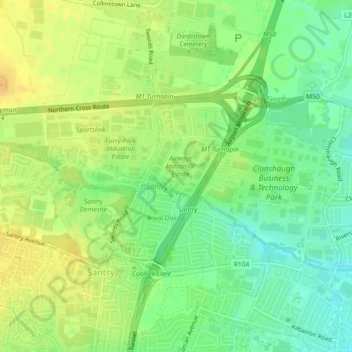
Nom : Carte topographique Turnapin DED 1986, altitude, relief.
Lieu : Turnapin DED 1986, Fingal, County Dublin, Leinster, Ireland (53.39733 -6.24413 53.41164 -6.22615)
Altitude moyenne : 53 m
Altitude minimum : 37 m
Altitude maximum : 66 m
Autres cartes topographiques
Cliquez sur une carte pour visualiser sa topographie, son altitude et son relief.
Kilcarbery Park
Kilcarbery Park, Clondalkin-Dunawley DED 1986, South Dublin, County Dublin, Leinster, Ireland
Altitude moyenne : 73 m
Marlay Park
Ireland > County Dublin > Ballyboden
Marlay Park, Ballinteer-Marley ED, Ballyboden, Dún Laoghaire-Rathdown, County Dublin, Leinster, Ireland
Altitude moyenne : 109 m
Iveagh Gardens
Ireland > County Dublin > Dublin
Iveagh Gardens, Saint Kevins Ward 1986, Dublin, County Dublin, Leinster, Ireland
Altitude moyenne : 17 m
Rowans Little
Rowans Little, Fingal, County Dublin, Leinster, Ireland
Altitude moyenne : 58 m
Dublin
Ireland > County Dublin > Dublin
Dublin, Dún Laoghaire-Rathdown, County Dublin, Leinster, Ireland
Altitude moyenne : 23 m
South Dublin
South Dublin, County Dublin, Leinster, Ireland
Altitude moyenne : 183 m
Dún Laoghaire-Rathdown
Dún Laoghaire-Rathdown, County Dublin, Leinster, Ireland
Altitude moyenne : 139 m
Portmarnock
Portmarnock, Fingal, County Dublin, Leinster, Ireland
Altitude moyenne : 6 m
Malahide (Union) 1900
Ireland > County Dublin > Malahide
Malahide (Union) 1900, Malahide, Fingal, County Dublin, Leinster, Ireland
Altitude moyenne : 12 m
Kilgobbin
Ireland > County Dublin > Stepaside
Kilgobbin, Glencullen Electoral Division, Stepaside, Dún Laoghaire-Rathdown, County Dublin, Leinster, Ireland
Altitude moyenne : 143 m
Priorswood
Ireland > County Dublin > Dublin
Priorswood, Priorswood E Ward 1986, Dublin, County Dublin, Leinster, D17 XV48, Ireland
Altitude moyenne : 42 m
Ballyboughal
Ballyboughal, Ballyboghil DED 1986, Fingal, County Dublin, Leinster, Ireland
Altitude moyenne : 35 m
Yellowmeadows
Yellowmeadows, Clondalkin-Monastery DED 1986, South Dublin, County Dublin, Leinster, Ireland
Altitude moyenne : 59 m
Clondalkin
Ireland > County Dublin > Clondalkin
Clondalkin, South Dublin, County Dublin, Leinster, Ireland
Altitude moyenne : 73 m
Swords
Ireland > County Dublin > Swords
Swords, Fingal, County Dublin, Leinster, K67 X8Y2, Ireland
Altitude moyenne : 28 m
Belinstown
Belinstown, Ballyboghil DED 1986, Fingal, County Dublin, Leinster, Ireland
Altitude moyenne : 32 m
Kill of the Grange
Kill of the Grange, Cabinteely-Pottery DED 1986, Dún Laoghaire-Rathdown, County Dublin, Leinster, Ireland
Altitude moyenne : 45 m
Huntstown
Huntstown, Dubber DED 1986, Fingal, County Dublin, Leinster, Ireland
Altitude moyenne : 67 m
Donabate
Donabate, Donabate DED 1986, Fingal, County Dublin, Leinster, Ireland
Altitude moyenne : 6 m
Malahide
Ireland > County Dublin > Malahide
Malahide, Fingal, County Dublin, Leinster, K36 HN84, Ireland
Altitude moyenne : 10 m
Liberty of Donore
Ireland > County Dublin > Dublin
Liberty of Donore, Kimmage C Ward 1986, Dublin, County Dublin, Leinster, Ireland
Altitude moyenne : 27 m
Lucan
Lucan, South Dublin, County Dublin, Leinster, K78 Y0F1, Ireland
Altitude moyenne : 59 m
Newcastle
Newcastle, South Dublin, County Dublin, Leinster, D22 XV65, Ireland
Altitude moyenne : 94 m
Ballyboden
Ballyboden, Rathfarnham-St. Enda's Electoral Division, South Dublin, County Dublin, Leinster, Ireland
Altitude moyenne : 82 m
Firhouse
Firhouse, Firhouse Village DED 1986, South Dublin, County Dublin, Leinster, Ireland
Altitude moyenne : 88 m
Clonsilla
Clonsilla, Fingal, County Dublin, Leinster, D15 T0HE, Ireland
Altitude moyenne : 59 m
Balgriffin
Balgriffin, Balgriffin ED, Fingal, County Dublin, Leinster, Ireland
Altitude moyenne : 26 m
Balbriggan
Balbriggan, Fingal, County Dublin, Leinster, Ireland
Altitude moyenne : 22 m
Darndale
Ireland > County Dublin > Dublin
Darndale, Priorswood C Ward 1986, Dublin, County Dublin, Leinster, Ireland
Altitude moyenne : 35 m
Bohernabreena
Bohernabreena, Bohernabreena DED 1986, South Dublin, County Dublin, Leinster, Ireland
Altitude moyenne : 142 m
Bluebell
Ireland > County Dublin > Dublin
Bluebell, Inchicore B Ward 1986, Dublin, County Dublin, Leinster, Ireland
Altitude moyenne : 44 m
Clonmethan
Clonmethan, Clonmethan DED 1971, Fingal, County Dublin, Leinster, Ireland
Altitude moyenne : 75 m
Balscadden DED 1971
Balscadden DED 1971, Fingal, County Dublin, Leinster, K32 WK07, Ireland
Altitude moyenne : 48 m
Ballyboden
Ballyboden, South Dublin, County Dublin, Leinster, D14 VY33, Ireland
Altitude moyenne : 83 m
Ballygall
Ireland > County Dublin > Dublin
Ballygall, Finglas East D ED, Dublin, County Dublin, Leinster, Ireland
Altitude moyenne : 53 m
Palmerstown
Palmerstown, South Dublin, County Dublin, Leinster, D20 TR50, Ireland
Altitude moyenne : 51 m
Ballyogan
Ballyogan, Dún Laoghaire-Rathdown, County Dublin, Leinster, D18 X456, Ireland
Altitude moyenne : 116 m
Stepaside
Stepaside, Dún Laoghaire-Rathdown, County Dublin, Leinster, D18 YR68, Ireland
Altitude moyenne : 183 m
Snugborough
Snugborough, Blanchardstown-Corduff DED 1986, Fingal, County Dublin, Leinster, Ireland
Altitude moyenne : 78 m
Garristown
Garristown, Fingal, County Dublin, Leinster, A42 Y437, Ireland
Altitude moyenne : 115 m
Tobergregan
Tobergregan, Fingal, County Dublin, Leinster, Ireland
Altitude moyenne : 114 m
Swords
Swords, Fingal, County Dublin, Leinster, Ireland
Altitude moyenne : 24 m
Glassamucky Brakes
Glassamucky Brakes, Bohernabreena DED 1986, South Dublin, County Dublin, Leinster, Ireland
Altitude moyenne : 405 m
Ballinascorney Upper
Ballinascorney Upper, Ballinascorney DED 1976, South Dublin, County Dublin, Leinster, Ireland
Altitude moyenne : 353 m
Skerries
Ireland > County Dublin > Skerries
Skerries, Fingal, County Dublin, Leinster, K34 V585, Ireland
Altitude moyenne : 16 m
Clondalkin, Lucan and Palmerston Parish
Ireland > County Dublin > Clondalkin
Clondalkin, Lucan and Palmerston Parish, Clondalkin, South Dublin, County Dublin, Leinster, Ireland
Altitude moyenne : 70 m
Rowlestown
Rowlestown, Fingal, County Dublin, Leinster, A41 NY52, Ireland
Altitude moyenne : 49 m