
Carte topographique Spink
Carte interactive
Cliquez sur la carte pour afficher l’altitude.
À propos de cette carte
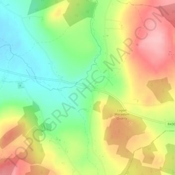
Nom : Carte topographique Spink, altitude, relief.
Altitude moyenne : 219 m
Altitude minimum : 154 m
Altitude maximum : 291 m
Autres cartes topographiques
Cliquez sur une carte pour visualiser sa topographie, son altitude et son relief.
Hewson Hill
Hewson Hill, The Municipal District of Portlaoise, County Laois, Leinster, R32 EY73, Ireland
Altitude moyenne : 152 m
Cross
Cross, Kildellig ED, The Municipal District of Borris-in-Ossory — Mountmellick, County Laois, Leinster, Ireland
Altitude moyenne : 107 m
The Municipal District of Borris-in-Ossory — Mountmellick
The Municipal District of Borris-in-Ossory — Mountmellick, County Laois, Leinster, Ireland
Altitude moyenne : 132 m
Lea
Lea, Kilmullen ED, The Municipal District of Graiguecullen — Portarlington, County Laois, Leinster, Ireland
Altitude moyenne : 71 m
Portlaoise
Ireland > County Laois > Portlaoise
Portlaoise, The Municipal District of Portlaoise, County Laois, Leinster, R32 DX07, Ireland
Altitude moyenne : 107 m
Ballacolla
Ireland > County Laois > Ballacolla
Ballacolla, The Municipal District of Borris-in-Ossory — Mountmellick, County Laois, Leinster, Ireland
Altitude moyenne : 90 m