
Carte topographique La Chapelle-Saint-Philibert
Carte interactive
Cliquez sur la carte pour afficher l’altitude.
À propos de cette carte
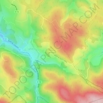
Nom : Carte topographique La Chapelle-Saint-Philibert, altitude, relief.
Altitude moyenne : 1 275 m
Altitude minimum : 1 137 m
Altitude maximum : 1 418 m
Autres cartes topographiques
Cliquez sur une carte pour visualiser sa topographie, son altitude et son relief.
Trespis
France > Auvergne-Rhône-Alpes > Ardèche > Lanarce
Trespis, Lanarce, Largentière, Ardèche, Auvergne-Rhône-Alpes, France métropolitaine, 07660, France
Altitude moyenne : 1 222 m