
Faire un don
Équipez-vous pour votre prochaine aventure :
En tant que Partenaire Amazon, ce site perçoit une commission sur les achats éligibles sans surcoût pour vous.
Carte topographique Tolè
Cliquez sur la carte pour afficher l’altitude.
Faire un don
Équipez-vous pour votre prochaine aventure :
En tant que Partenaire Amazon, ce site perçoit une commission sur les achats éligibles sans surcoût pour vous.
À propos de cette carte
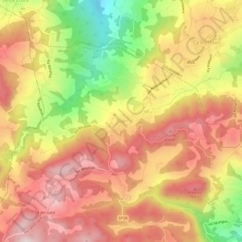
Nom : Carte topographique Tolè, altitude, relief.
Altitude moyenne : 665 m
Altitude minimum : 394 m
Altitude maximum : 851 m
Faire un don
Équipez-vous pour votre prochaine aventure :
En tant que Partenaire Amazon, ce site perçoit une commission sur les achats éligibles sans surcoût pour vous.
Autres cartes topographiques
Cliquez sur une carte pour visualiser sa topographie, son altitude et son relief.
Bologna
Italy > Emilia-Romagna > Bologna
Bologna is situated on the edge of the Po Plain at the foot of the Apennine Mountains, at the meeting of the Reno and Savena river valleys. As Bologna's two main watercourses flow directly to the sea, the town lies outside of the drainage basin of the River Po. The Province of Bologna stretches from the…
Altitude moyenne : 91 m
Faire un don
Équipez-vous pour votre prochaine aventure :
En tant que Partenaire Amazon, ce site perçoit une commission sur les achats éligibles sans surcoût pour vous.
Bologna
Italy > Emilia-Romagna > Bologna
Bologna is situated on the edge of the Po Plain at the foot of the Apennine Mountains, at the meeting of the Reno and Savena river valleys. As Bologna's two main watercourses flow directly to the sea, the town lies outside of the drainage basin of the River Po. The province of Bologna stretches from the…
Altitude moyenne : 91 m
Faire un don
Équipez-vous pour votre prochaine aventure :
En tant que Partenaire Amazon, ce site perçoit une commission sur les achats éligibles sans surcoût pour vous.
Bologna
Italy > Emilia-Romagna > Bologna
Bologna is situated on the edge of the Po Plain at the foot of the Apennine Mountains, at the meeting of the Reno and Savena river valleys. As Bologna's two main watercourses flow directly to the sea, the town lies outside of the drainage basin of the River Po. The Province of Bologna stretches from the…
Altitude moyenne : 91 m
Faire un don
Équipez-vous pour votre prochaine aventure :
En tant que Partenaire Amazon, ce site perçoit une commission sur les achats éligibles sans surcoût pour vous.
Monghidoro
Italy > Emilia-Romagna > Bologna
The territory surrounding the municipality is, for the largest part, mountainous with elevations ranging between a minimum of 400 metres (1,300 ft) above sea level to the north-east to a maximum of 1,290 metres (4,230 ft) on its southern flank.
Altitude moyenne : 732 m
Faire un don
Équipez-vous pour votre prochaine aventure :
En tant que Partenaire Amazon, ce site perçoit une commission sur les achats éligibles sans surcoût pour vous.
Faire un don
Équipez-vous pour votre prochaine aventure :
En tant que Partenaire Amazon, ce site perçoit une commission sur les achats éligibles sans surcoût pour vous.
Bologna
Italy > Emilia-Romagna > Bologna
Bologna is situated on the edge of the Po Plain at the foot of the Apennine Mountains, at the meeting of the Reno and Savena river valleys. As Bologna's two main watercourses flow directly to the sea, the town lies outside of the drainage basin of the River Po. The Province of Bologna stretches from the…
Altitude moyenne : 91 m
Faire un don
Équipez-vous pour votre prochaine aventure :
En tant que Partenaire Amazon, ce site perçoit une commission sur les achats éligibles sans surcoût pour vous.