
Carte topographique Malham
Carte interactive
Cliquez sur la carte pour afficher l’altitude.
À propos de cette carte
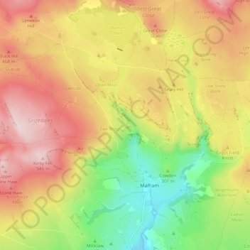
Nom : Carte topographique Malham, altitude, relief.
Lieu : Malham, North Yorkshire, England, United Kingdom (54.05408 -2.20986 54.09540 -2.11451)
Altitude moyenne : 371 m
Altitude minimum : 178 m
Altitude maximum : 552 m
Autres cartes topographiques
Cliquez sur une carte pour visualiser sa topographie, son altitude et son relief.
Cow Hill
United Kingdom > England > North Yorkshire > Halton West
Cow Hill, Halton West, North Yorkshire, England, BD23 4LP, United Kingdom
Altitude moyenne : 145 m
Settle
United Kingdom > England > North Yorkshire
Settle, North Yorkshire, England, United Kingdom
Altitude moyenne : 238 m
Middleham
United Kingdom > England > North Yorkshire
Middleham, North Yorkshire, England, United Kingdom
Altitude moyenne : 157 m
Scarborough
United Kingdom > England > North Yorkshire > Scarborough
Scarborough, North Yorkshire, Yorkshire and the Humber, England, United Kingdom
Altitude moyenne : 50 m