
Carte topographique Sanmenxia City
Carte interactive
Cliquez sur la carte pour afficher l’altitude.
À propos de cette carte
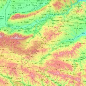
Nom : Carte topographique Sanmenxia City, altitude, relief.
Lieu : Sanmenxia City, Henan, China (33.54968 110.35511 35.08418 112.02556)
Altitude moyenne : 842 m
Altitude minimum : 206 m
Altitude maximum : 2 307 m
Sanmenxia is located in western Henan on the southern (right) bank of the Yellow River, and is surrounded on three sides by mountains, with elevations generally increasing from northeast to southwest. Most of the prefecture is at an altitude of 300 to 1,500 metres (980 to 4,920 ft), although the highest peak in the province, at 2,413.8 metres (7,919 ft), is located in Lingbao. The prefecture is at the intersection of Henan, Shanxi, and Shaanxi provinces, bordering Luoyang to the east, Nanyang to the south, Weinan (Shaanxi) to the west, and Yuncheng (Shanxi) to the north across the Yellow River.
Autres cartes topographiques
Cliquez sur une carte pour visualiser sa topographie, son altitude et son relief.
Daxingnanjiecun
China > Henan > Tangyin County
Daxingnanjiecun, Tangyin County, Anyang, Henan, China
Altitude moyenne : 85 m
Xinyang
China > Henan > Qianjin Subdistrict
Xinyang, Qianjin Subdistrict, Pingqiao District, Xinyang, Henan, China
Altitude moyenne : 105 m
Kaifeng
China > Henan > Gulou District > Xiangguosi Subdistrict
Kaifeng, Xiangguosi Subdistrict, Gulou District, Kaifeng, Henan, China
Altitude moyenne : 75 m
Mengjin District
Mengjin District, Luoyang, Mengjin, Henan, China
Altitude moyenne : 247 m
Pengpo
China > Henan > Yichuan County > Luoyang
Pengpo, Yichuan County, Luoyang, Henan, China
Altitude moyenne : 230 m
Runan County
China > Henan > Zhumadian City
Runan County, Zhumadian City, Henan, China
Altitude moyenne : 63 m