
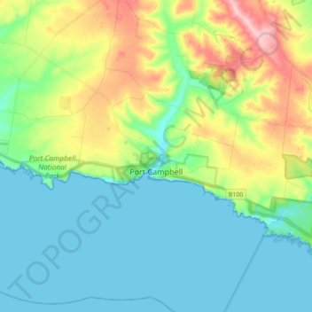
Carte topographique Port Campbell
Carte interactive
Cliquez sur la carte pour afficher l’altitude.
À propos de cette carte
Nom : Carte topographique Port Campbell, altitude, relief.
Altitude moyenne : 46 m
Altitude minimum : 0 m
Altitude maximum : 161 m
Autres cartes topographiques
Cliquez sur une carte pour visualiser sa topographie, son altitude et son relief.
Shire of Central Goldfields
Shire of Central Goldfields, Victoria, Australia
Altitude moyenne : 234 m
Templestowe Lower
Australia > Victoria > Melbourne
Templestowe Lower, Melbourne, City of Manningham, Victoria, 3107, Australia
Altitude moyenne : 55 m
Lake Eppalock
Lake Eppalock, City of Greater Bendigo, Victoria, Australia
Altitude moyenne : 219 m
Lake Eildon
Lake Eildon, Shire of Mansfield, Victoria, Australia
Altitude moyenne : 386 m
Melbourne Water Reserve
Australia > Victoria > Melbourne
Melbourne Water Reserve, Warrandyte South, Melbourne, City of Manningham, Victoria, Australia
Altitude moyenne : 127 m
Warburton
Australia > Victoria > Big Pats Creek
Warburton, Big Pats Creek, Shire of Yarra Ranges, Victoria, 3799, Australia
Altitude moyenne : 422 m
Burwood District
Australia > Victoria > Melbourne > Burwood
Burwood District, Burwood, Melbourne, City of Whitehorse, Victoria, 3125, Australia
Altitude moyenne : 73 m
Clifton Creek
Australia > Victoria > Wy Yung
Clifton Creek, Wy Yung, Shire of East Gippsland, Victoria, 3875, Australia
Altitude moyenne : 23 m
Hotham Heights
Australia > Victoria > Hotham Heights
Hotham Heights, Hume, Victoria, Australia
Altitude moyenne : 1 601 m
Shire of Corangamite
Shire of Corangamite, Barwon South West, Victoria, Australia
Altitude moyenne : 151 m
City of Greater Dandenong
City of Greater Dandenong, Victoria, Australia
Altitude moyenne : 33 m
Beechworth
Australia > Victoria > Beechworth
Beechworth, Shire of Indigo, Hume, Victoria, 3747, Australia
Altitude moyenne : 533 m
City of Moonee Valley
City of Moonee Valley, Victoria, Australia
Altitude moyenne : 48 m
Manifold Heights
Australia > Victoria > Geelong
Manifold Heights, Geelong, City of Greater Geelong, Barwon South West, Victoria, 3218, Australia
Altitude moyenne : 41 m
Springvale
Springvale, City of Greater Dandenong, Victoria, 3171, Australia
Altitude moyenne : 59 m
Greater Bendigo (future addition)
Australia > Victoria > Bendigo
Greater Bendigo (future addition), Bendigo Bushland Trail, Spring Gully, Bendigo, City of Greater Bendigo, Loddon Mallee, Victoria, 3550, Australia
Altitude moyenne : 272 m
Wingan River
Wingan River, Shire of East Gippsland, Gippsland, Victoria, Australia
Altitude moyenne : 131 m
Badger Creek
Australia > Victoria > Healesville
Badger Creek, Healesville, Shire of Yarra Ranges, Victoria, Australia
Altitude moyenne : 255 m
Wilsons Promontory
Wilsons Promontory, Shire of South Gippsland, Gippsland, Victoria, Australia
Altitude moyenne : 28 m
Croajingolong National Park
Croajingolong National Park, Lake Barracotta Link Track, Genoa, Shire of East Gippsland, Gippsland, Victoria, Australia
Altitude moyenne : 50 m
Mount Feathertop
Mount Feathertop, Alpine Shire, Hume, Victoria, Australia
Altitude moyenne : 1 533 m
Mount Dawson
Mount Dawson, Shire of East Gippsland, Gippsland, Victoria, Australia
Altitude moyenne : 435 m
Hattah - Kulkyne National Park
Australia > Victoria > Colignan
Hattah - Kulkyne National Park, Reed Road, Hattah, Colignan, Rural City of Mildura, Loddon Mallee, Victoria, Australia
Altitude moyenne : 51 m
Wilsons Promontory National Park
Wilsons Promontory National Park, Vereker Outlook, Wilsons Promontory, Shire of South Gippsland, Gippsland, Victoria, Australia
Altitude moyenne : 32 m