
Carte topographique Rafsanjan
Carte interactive
Cliquez sur la carte pour afficher l’altitude.
À propos de cette carte
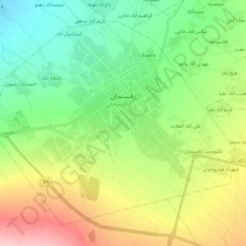
Nom : Carte topographique Rafsanjan, altitude, relief.
Lieu : Rafsanjan, بخش مرکزی, Rafsanjan County, Kerman Province, Iran (30.32710 55.90445 30.44527 56.06907)
Altitude moyenne : 1 539 m
Altitude minimum : 1 477 m
Altitude maximum : 1 653 m
Rafsanjan is located in south part of the Lut desert, in north-west of Kerman province. The longitude of this city is 56 degrees east and the latitude is 30 degrees south. The Average distance between Kerman and this city is 110 km (68 mi). The city has an airport and railway (Tehran-Bandar Abbas route). Moreover, the altitude is 1,460 m (4,790 ft) and the land-measurement is approximately 10,687 km (6,641 mi). North part of Rafsanjan has a common frontier with Bafgh and Zarand; south part is neighboring with Bardsir and on west side with Anar and Shahre-Babak; finally east side of this city is neighboring with Kerman and Zarand. Rafsanjan has two seasonal rivers named as Shour and Giouderi. The mountains in the area are part of Zagros range, and Sarcheshmeh and Davaran are the most famous.
Autres cartes topographiques
Cliquez sur une carte pour visualiser sa topographie, son altitude et son relief.
دهستان بهرمان
Iran > Kerman Province > Rafsanjan County
دهستان بهرمان, بخش نوق, Rafsanjan County, Kerman Province, Iran
Altitude moyenne : 1 463 m