
Carte topographique Shrewsbury
Carte interactive
Cliquez sur la carte pour afficher l’altitude.
Shrewsbury
The town centre is partially built on a hill whose elevation is, at its highest, 246 feet (75 m) above sea level. The longest river in the United Kingdom, the River Severn, flows through the town, forming a meander around its centre. The Rea Brook is a small river that has its confluence with the Severn at Shrewsbury, just upstream from the English Bridge, and much of the Rea Brook Valley within the town is a country park and local nature reserve, encompassing 36 hectares (89 acres). The town is subject to flooding from these rivers.
À propos de cette carte
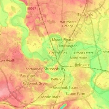
Nom : Carte topographique Shrewsbury, altitude, relief.
Lieu : Shrewsbury, Shropshire, England, United Kingdom (52.68019 -2.81432 52.75498 -2.70122)
Altitude moyenne : 69 m
Altitude minimum : 19 m
Altitude maximum : 103 m
Autres cartes topographiques
Cliquez sur une carte pour visualiser sa topographie, son altitude et son relief.