
Carte topographique Jabal Qasiyun
Carte interactive
Cliquez sur la carte pour afficher l’altitude.
À propos de cette carte
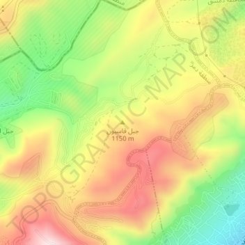
Nom : Carte topographique Jabal Qasiyun, altitude, relief.
Altitude moyenne : 946 m
Altitude minimum : 735 m
Altitude maximum : 1 142 m
The mountain is also host to an endemic species of iris, Iris damascena, which can be found on the steep eastern slopes, at an altitude of 1,200 m (3,900 ft) above sea level.[5] The Syrian government has not given the species any protected status. Its only benefiting factor was that part of the habitat of the species lies within a military area near the 'Qassioun Republican Guards Military Base' and other military facilities, which prevents civilians from accessing the area.[6] The base and steepness of the habitat also prevents construction or development, but it is still classified as Critically endangered.[7]