
Carte topographique Xanthi
Carte interactive
Cliquez sur la carte pour afficher l’altitude.
À propos de cette carte
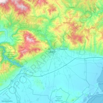
Nom : Carte topographique Xanthi, altitude, relief.
Altitude moyenne : 311 m
Altitude minimum : -5 m
Altitude maximum : 1 408 m
Autres cartes topographiques
Cliquez sur une carte pour visualiser sa topographie, son altitude et son relief.
Συδινή
Greece > Macedonia and Thrace > Xanthi Regional Unit
Συδινή, Abdera Municipality, Xanthi Regional Unit, Eastern Macedonia and Thrace, Macedonia and Thrace, 670 64, Greece
Altitude moyenne : 13 m
Κόσυνθος
Greece > Macedonia and Thrace > Xanthi Regional Unit
Κόσυνθος, Xanthi Regional Unit, Eastern Macedonia and Thrace, Macedonia and Thrace, 67132, Greece
Altitude moyenne : 423 m