
Carte topographique Buntingford
Carte interactive
Cliquez sur la carte pour afficher l’altitude.
À propos de cette carte
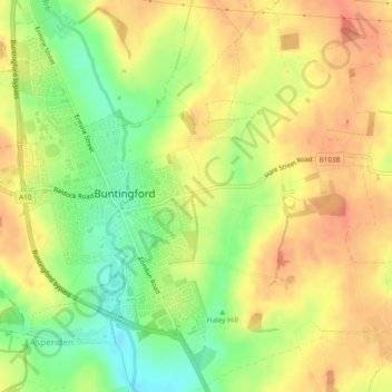
Nom : Carte topographique Buntingford, altitude, relief.
Altitude moyenne : 110 m
Altitude minimum : 81 m
Altitude maximum : 129 m
Autres cartes topographiques
Cliquez sur une carte pour visualiser sa topographie, son altitude et son relief.
Pelham Gate
United Kingdom > England > Hertfordshire > East Hertfordshire
Pelham Gate, Brent Pelham, East Hertfordshire, Hertfordshire, England, SG9 0HL, United Kingdom
Altitude moyenne : 113 m
Much Hadham
United Kingdom > England > Hertfordshire > East Hertfordshire
Much Hadham, East Hertfordshire, Hertfordshire, England, United Kingdom
Altitude moyenne : 80 m
Bishops Stortford Elsan Point
United Kingdom > England > Hertfordshire > East Hertfordshire
Bishops Stortford Elsan Point, East Hertfordshire, Hertfordshire, East of England, England, CM23 3BL, United Kingdom
Altitude moyenne : 78 m
Thorley
United Kingdom > England > Hertfordshire > East Hertfordshire > Thorley
Thorley, East Hertfordshire, Hertfordshire, East of England, England, United Kingdom
Altitude moyenne : 82 m