
Carte topographique Robert Moses State Park (Long Island)
Carte interactive
Cliquez sur la carte pour afficher l’altitude.
À propos de cette carte
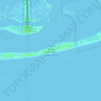
Nom : Carte topographique Robert Moses State Park (Long Island), altitude, relief.
Altitude moyenne : 0 m
Altitude minimum : -5 m
Altitude maximum : 12 m
Autres cartes topographiques
Cliquez sur une carte pour visualiser sa topographie, son altitude et son relief.
Village of Amityville
United States > New York > Suffolk County > Town of Babylon
Village of Amityville, Town of Babylon, Suffolk County, New York, United States
Altitude moyenne : 6 m
Village of Babylon
United States > New York > Suffolk County > Town of Babylon
Village of Babylon, Town of Babylon, Suffolk County, New York, 11702, United States
Altitude moyenne : 4 m
Wheatley Heights
United States > New York > Suffolk County > Town of Babylon > Wheatley Heights
Wheatley Heights, Town of Babylon, Suffolk County, New York, United States
Altitude moyenne : 35 m