
Carte topographique Seabrook
Carte interactive
Cliquez sur la carte pour afficher l’altitude.
À propos de cette carte
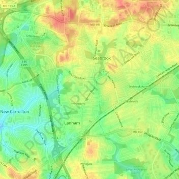
Nom : Carte topographique Seabrook, altitude, relief.
Altitude moyenne : 49 m
Altitude minimum : 22 m
Altitude maximum : 75 m
Seabrook takes its name from Thomas Seabrook, who was a topographical engineer with the Pennsylvania Railroad. He originally built three cottages and a park with fenced-in tame deer in the area near the rail station[5] in the early 1870s.
Autres cartes topographiques
Cliquez sur une carte pour visualiser sa topographie, son altitude et son relief.
Lanham
United States > Maryland > Prince George's County > Glenn Dale
Lanham, Glenn Dale, Prince George's County, Maryland, 20706, United States
Altitude moyenne : 47 m