
Carte topographique Kasanka National Park
Carte interactive
Cliquez sur la carte pour afficher l’altitude.
À propos de cette carte
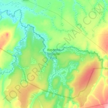
Nom : Carte topographique Kasanka National Park, altitude, relief.
Altitude moyenne : 1 208 m
Altitude minimum : 1 170 m
Altitude maximum : 1 294 m
Kasanka National Park is a park located in the Chitambo District of Zambia’s Central Province. At roughly 390 km2 (150 sq mi), Kasanka is one of Zambia’s smallest national parks. Kasanka was the first of Zambia’s national parks to be managed by a private-public partnership. The privately funded Kasanka Trust Ltd has been in operation since 1986 and undertakes all management responsibilities, in partnership with the Department of National Parks and Wildlife (DNPW - previously ZAWA). The park has an average elevation between 1,160 m (3,810 ft) and 1,290 m (4,230 ft) above mean sea level. It has a number permanent shallow lakes and water bodies with the largest being Wasa. There are five perennial rivers in the park, with the largest being the Luwombwa River. The Luwombwa is the only river that drains the NP, which flows out in the northwestern corner. It is a tributary of the Luapula, which further upstream also drains the Bangweulu Swamp and forms the main source of the Congo River. Although Kasanka NP is part of the Greater Bangweulu Ecosystem, there is no direct hydrological connection between the park and the Bangweulu Wetlands.
Autres cartes topographiques
Cliquez sur une carte pour visualiser sa topographie, son altitude et son relief.
Lika
Lika, Serenje District, Central Province, Zambia
Altitude moyenne : 1 499 m
Lunsemfwa
Lunsemfwa, Luano District, Central Province, Zambia
Altitude moyenne : 1 110 m
Kapiri Mposhi
Kapiri Mposhi, Kapiri Mposhi District, Central Province, Zambia
Altitude moyenne : 1 263 m
Chititima
Chititima, Chitambo District, Central Province, Zambia
Altitude moyenne : 1 203 m
Mita Hills Dam
Mita Hills Dam, Luano District, Central Province, Zambia
Altitude moyenne : 1 108 m
Mkushi
Zambia > Central Province > Mkushi
Mkushi, Mkushi District, Central Province, Zambia
Altitude moyenne : 1 281 m
Serenje
Zambia > Central Province > Serenje
Serenje, Serenje District, Central Province, Zambia
Altitude moyenne : 1 430 m
Chisamba
Zambia > Central Province > Chisamba
Chisamba, Chisamba District, Central Province, Zambia
Altitude moyenne : 1 144 m
Lunsemfwa River
Lunsemfwa River, Central Province, Zambia
Altitude moyenne : 997 m