
Carte topographique Limp
Carte interactive
Cliquez sur la carte pour afficher l’altitude.
À propos de cette carte
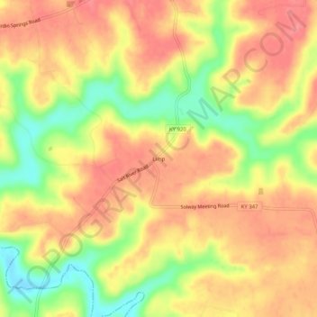
Nom : Carte topographique Limp, altitude, relief.
Lieu : Limp, Hardin County, Kentucky, United States (37.57228 -86.21747 37.61228 -86.17747)
Altitude moyenne : 211 m
Altitude minimum : 163 m
Altitude maximum : 239 m
Autres cartes topographiques
Cliquez sur une carte pour visualiser sa topographie, son altitude et son relief.
Elizabethtown
United States > Kentucky > Hardin County
Elizabethtown, Hardin County, Kentucky, 42701, United States
Altitude moyenne : 241 m
West Point
United States > Kentucky > Hardin County
West Point, Hardin County, Kentucky, United States
Altitude moyenne : 163 m
Hardin County
United States > Kentucky > Hardin County
Hardin County, Kentucky, United States
Altitude moyenne : 212 m
Cecil Hill
United States > Kentucky > Hardin County
Cecil Hill, Hardin County, Kentucky, 42724, United States
Altitude moyenne : 230 m
Kraft
United States > Kentucky > Hardin County
Kraft, Hardin County, Kentucky, 40162, United States
Altitude moyenne : 247 m
Vine Grove
United States > Kentucky > Hardin County
Vine Grove, Hardin County, Kentucky, United States
Altitude moyenne : 218 m
West Point
United States > Kentucky > Hardin County > West Point
West Point, Hardin County, Kentucky, 40177, United States
Altitude moyenne : 169 m
Radcliff
United States > Kentucky > Hardin County
Radcliff, Hardin County, Kentucky, 40160, United States
Altitude moyenne : 223 m