
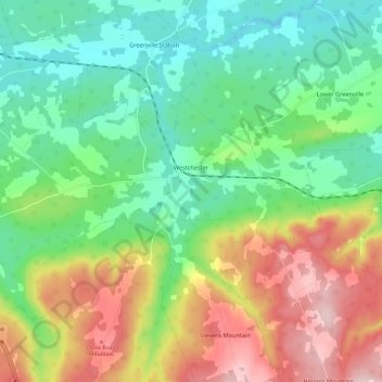
Carte topographique Westchester
Carte interactive
Cliquez sur la carte pour afficher l’altitude.
À propos de cette carte
Nom : Carte topographique Westchester, altitude, relief.
Altitude moyenne : 157 m
Altitude minimum : 55 m
Altitude maximum : 331 m
Autres cartes topographiques
Cliquez sur une carte pour visualiser sa topographie, son altitude et son relief.
Mapleton
Canada > Nova Scotia > Municipality of the County of Cumberland
Mapleton, Municipality of the County of Cumberland, Cumberland County, Nova Scotia, B0M 1W0, Canada
Altitude moyenne : 102 m
Beckwith
Canada > Nova Scotia > Municipality of the County of Cumberland
Beckwith, Municipality of the County of Cumberland, Cumberland County, Nova Scotia, Canada
Altitude moyenne : 44 m
Northport
Canada > Nova Scotia > Municipality of the County of Cumberland
Northport, Municipality of the County of Cumberland, Cumberland County, Nova Scotia, B0L 1E0, Canada
Altitude moyenne : 12 m
Maccan
Canada > Nova Scotia > Municipality of the County of Cumberland
Maccan, Municipality of the County of Cumberland, Cumberland County, Nova Scotia, B0L 1B0, Canada
Altitude moyenne : 45 m
Parrsboro
Canada > Nova Scotia > Municipality of the County of Cumberland
Parrsboro, Municipality of the County of Cumberland, Cumberland County, Nova Scotia, B0M 1S0, Canada
Altitude moyenne : 25 m
Gulf Shore
Canada > Nova Scotia > Municipality of the County of Cumberland > Gulf Shore
Gulf Shore, Municipality of the County of Cumberland, Cumberland County, Nova Scotia, B0K 1L0, Canada
Altitude moyenne : 11 m