
Carte topographique Brainerd
Carte interactive
Cliquez sur la carte pour afficher l’altitude.
À propos de cette carte
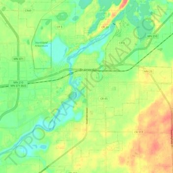
Nom : Carte topographique Brainerd, altitude, relief.
Lieu : Brainerd, Crow Wing County, Minnesota, 56401, United States (46.31263 -94.24592 46.38862 -94.14238)
Altitude moyenne : 370 m
Altitude minimum : 348 m
Altitude maximum : 395 m
Autres cartes topographiques
Cliquez sur une carte pour visualiser sa topographie, son altitude et son relief.
Duck Lake
United States > Minnesota > Crow Wing County > Crosslake
Duck Lake, Crosslake, Crow Wing County, Minnesota, United States
Altitude moyenne : 377 m
Ruth Lake
United States > Minnesota > Crow Wing County > Emily
Ruth Lake, Emily, Crow Wing County, Minnesota, United States
Altitude moyenne : 391 m
Pequot Terrace
United States > Minnesota > Crow Wing County > Nisswa
Pequot Terrace, Nisswa, Crow Wing County, Minnesota, 56468, United States
Altitude moyenne : 372 m
Saint Mathias
United States > Minnesota > Crow Wing County > Saint Mathias
Saint Mathias, Crow Wing County, Minnesota, United States
Altitude moyenne : 369 m
Emily
United States > Minnesota > Crow Wing County > Emily
Emily, Crow Wing County, Minnesota, 56447, United States
Altitude moyenne : 393 m
Breezy Point
United States > Minnesota > Crow Wing County
Breezy Point, Crow Wing County, Minnesota, United States
Altitude moyenne : 377 m