
Carte topographique Tualatin River
Carte interactive
Cliquez sur la carte pour afficher l’altitude.
À propos de cette carte
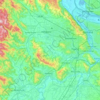
Nom : Carte topographique Tualatin River, altitude, relief.
Lieu : Tualatin River, Washington County, Oregon, United States (45.33804 -123.40799 45.51229 -122.64732)
Altitude moyenne : 117 m
Altitude minimum : -3 m
Altitude maximum : 740 m
The drainage area of the river is approximately 712 square miles (1,840 km2) with 27 creeks feeding into the Tualatin. Its watershed is 15 percent urbanized, 35 percent agricultural, and 50 percent forested. The river drops 1,800 feet (550 m) in elevation during its first 12 miles (19 km) and then only an additional 250 feet (76 m) for the remaining 71 miles (114 km) of its course. This creates a slow river for the majority of the course, creating problems with pollution. Pollution reached a point that in 1989 local agencies were forced to begin cleaning up the river after the Tualatin failed water quality standards outlined in the Clean Water Act of 1972. It was the first river in the state to fail overall pollution limits.
Autres cartes topographiques
Cliquez sur une carte pour visualiser sa topographie, son altitude et son relief.
Hillsboro
United States > Oregon > Washington County
Hillsboro, Washington County, Oregon, United States
Altitude moyenne : 53 m
Tigard
United States > Oregon > Washington County
Tigard, Washington County, Oregon, United States
Altitude moyenne : 83 m
Sherwood
United States > Oregon > Washington County
Sherwood, Washington County, Oregon, 97140, United States
Altitude moyenne : 68 m
Beaverton
United States > Oregon > Washington County
Beaverton, Washington County, Oregon, United States
Altitude moyenne : 106 m
Forest Grove
United States > Oregon > Washington County
Forest Grove, Washington County, Oregon, 97116, United States
Altitude moyenne : 61 m
Banks
United States > Oregon > Washington County
Banks, Washington County, Oregon, 97106, United States
Altitude moyenne : 70 m
Laurelwood
United States > Oregon > Washington County
Laurelwood, Washington County, Oregon, United States
Altitude moyenne : 165 m
North Plains
United States > Oregon > Washington County
North Plains, Washington County, Oregon, United States
Altitude moyenne : 57 m
Tualatin
United States > Oregon > Washington County
Tualatin, Washington County, Oregon, 97062, United States
Altitude moyenne : 70 m
L.L. Stub Stewart State Park
United States > Oregon > Washington County
L.L. Stub Stewart State Park, Service Road, Washington County, Oregon, 97109, United States
Altitude moyenne : 299 m
Rock Creek
United States > Oregon > Washington County
Rock Creek, Washington County, Oregon, United States
Altitude moyenne : 65 m
Chehalem
United States > Oregon > Washington County
Chehalem, Washington County, Oregon, 97140, United States
Altitude moyenne : 181 m
Vose
United States > Oregon > Washington County > Beaverton
Vose, Beaverton, Washington County, Oregon, United States
Altitude moyenne : 70 m
Denney Whitford/Raleigh West
United States > Oregon > Washington County > Beaverton
Denney Whitford/Raleigh West, Beaverton, Washington County, Oregon, United States
Altitude moyenne : 72 m
Cornelius
United States > Oregon > Washington County
Cornelius, Washington County, Oregon, United States
Altitude moyenne : 50 m
King City
United States > Oregon > Washington County
King City, Washington County, Oregon, United States
Altitude moyenne : 74 m
Timber
United States > Oregon > Washington County
Timber, Washington County, Oregon, 97144, United States
Altitude moyenne : 319 m
Pendelton Creek
United States > Oregon > Washington County > Portland
Pendelton Creek, Raleigh Hills, Portland, Washington County, Oregon, 97221, United States
Altitude moyenne : 100 m
Gaston
United States > Oregon > Washington County
Gaston, Washington County, Oregon, United States
Altitude moyenne : 66 m