
Carte topographique Rotenburg an der Fulda
Carte interactive
Cliquez sur la carte pour afficher l’altitude.
À propos de cette carte
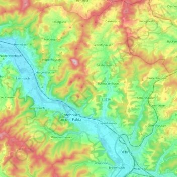
Nom : Carte topographique Rotenburg an der Fulda, altitude, relief.
Altitude moyenne : 310 m
Altitude minimum : 177 m
Altitude maximum : 540 m
Autres cartes topographiques
Cliquez sur une carte pour visualiser sa topographie, son altitude et son relief.
Kirchheim
Duitsland > Hessen > Landkreis Hersfeld-Rotenburg
Kirchheim, Landkreis Hersfeld-Rotenburg, Hessen, 36275, Duitsland
Altitude moyenne : 357 m
Bad Hersfeld
Duitsland > Hessen > Landkreis Hersfeld-Rotenburg
Bad Hersfeld, Landkreis Hersfeld-Rotenburg, Hessen, 36251, Duitsland
Altitude moyenne : 281 m