
Carte topographique Brunnen
Carte interactive
Cliquez sur la carte pour afficher l’altitude.
À propos de cette carte
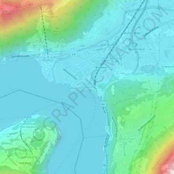
Nom : Carte topographique Brunnen, altitude, relief.
Lieu : Brunnen, Ingenbohl, Schwyz, 6440, Zwitserland (46.97404 8.58541 47.01404 8.62541)
Altitude moyenne : 592 m
Altitude minimum : 402 m
Altitude maximum : 1 568 m
Autres cartes topographiques
Cliquez sur une carte pour visualiser sa topographie, son altitude et son relief.
Rothenthurm
Zwitserland > Schwyz > Schwyz > Rothenthurm
Rothenthurm, Schwyz, 6418, Zwitserland
Altitude moyenne : 1 035 m