
Carte topographique Wallowa Mountains
Carte interactive
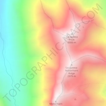
Cliquez sur la carte pour afficher l’altitude.
À propos de cette carte
Nom : Carte topographique Wallowa Mountains, altitude, relief.
Lieu : Wallowa Mountains, Wallowa County, Oregon, USA (45.23995 -117.30005 45.24005 -117.29995)
Altitude moyenne : 2 475 m
Altitude minimum : 1 850 m
Altitude maximum : 2 986 m
Autres cartes topographiques
Cliquez sur une carte pour visualiser sa topographie, son altitude et son relief.
The Villages at Mount Hood
USA > Oregon > The Villages at Mount Hood
The Villages at Mount Hood, Clackamas County, Oregon, USA
Altitude moyenne : 797 m
Jefferson Park Glacier
Jefferson Park Glacier, Pacific Crest Trail #2000, Jefferson County, Oregon, USA
Altitude moyenne : 2 421 m
Linn Glacier
Linn Glacier, Pacific Crest Trail, Deschutes County, Oregon, USA
Altitude moyenne : 2 359 m
Whitewater Glacier
Whitewater Glacier, Pacific Crest Trail, Jefferson County, Oregon, USA
Altitude moyenne : 2 460 m
Cascade Head
USA > Oregon > Three Rocks
Cascade Head, Cascade Head Trail, Three Rocks, Tillamook County, Oregon, 97149, USA
Altitude moyenne : 50 m
Bend Glacier
Bend Glacier, Broken Top NW Ridge route, Deschutes County, Oregon, USA
Altitude moyenne : 2 350 m
Hayden Glacier
Hayden Glacier, climber's trail, Deschutes County, Oregon, USA
Altitude moyenne : 2 542 m
Eliot Glacier
Eliot Glacier, Eliot west moraine, Hood River County, Oregon, USA
Altitude moyenne : 2 316 m
Zigzag Glacier
Zigzag Glacier, Mountaineer Trail #798, Clackamas County, Oregon, USA
Altitude moyenne : 2 620 m
Renfrew Glacier
Renfrew Glacier, climber's trail, Deschutes County, Oregon, USA
Altitude moyenne : 2 538 m
Glisan Glacier
Glisan Glacier, McNeil Point Trail #600M, Hood River County, Oregon, USA
Altitude moyenne : 2 086 m
Carver Glacier
Carver Glacier, South Sister Climber Trail #36, Deschutes County, Oregon, USA
Altitude moyenne : 2 385 m
Reid Glacier
Reid Glacier, Yocum Ridge Trail #771, Clackamas County, Oregon, USA
Altitude moyenne : 2 410 m
Ladd Glacier
Ladd Glacier, Barrett Spur, Hood River County, Oregon, USA
Altitude moyenne : 2 305 m
Langille Glacier
Langille Glacier, Eliot west moraine, Hood River County, Oregon, USA
Altitude moyenne : 2 165 m
Villard Glacier
Villard Glacier, climber's trail, Deschutes County, Oregon, USA
Altitude moyenne : 2 448 m
Irving Glacier
Irving Glacier, Camp Lake Trail, Deschutes County, Oregon, USA
Altitude moyenne : 2 344 m
Skinner Glacier
Skinner Glacier, South Sister Climber Trail #36, Deschutes County, Oregon, USA
Altitude moyenne : 2 480 m
Benson Glacier
Benson Glacier, Eagle Cap Summit Trail, Union County, Oregon, USA
Altitude moyenne : 2 489 m
Three Fingered Jack
Three Fingered Jack, Linn County, Oregon, USA
Altitude moyenne : 1 881 m
Waldo Glacier
Waldo Glacier, Pacific Crest Trail, Jefferson County, Oregon, USA
Altitude moyenne : 2 352 m
Prouty Glacier
Prouty Glacier, South Sister Climber Trail #36, Deschutes County, Oregon, USA
Altitude moyenne : 2 589 m
Clark Glacier
Clark Glacier, South Sister Climber Trail #36, Deschutes County, Oregon, USA
Altitude moyenne : 2 578 m
Crook Glacier
Crook Glacier, Broken Top NW Ridge route, Deschutes County, Oregon, USA
Altitude moyenne : 2 347 m
White River Glacier
White River Glacier, Mountaineer Trail #798, Clackamas County, Oregon, USA
Altitude moyenne : 2 523 m
Lathrop Glacier
Lathrop Glacier, Mt. Thielsen climber's trail, Douglas County, Oregon, USA
Altitude moyenne : 2 235 m