
Merci de soutenir ce site ❤️
Faire un don
Faire un don
Équipez-vous pour votre prochaine aventure :
En tant que Partenaire Amazon, ce site perçoit une commission sur les achats éligibles sans surcoût pour vous.
Carte topographique Aru
Cliquez sur la carte pour afficher l’altitude.
Merci de soutenir ce site ❤️
Faire un don
Faire un don
Équipez-vous pour votre prochaine aventure :
En tant que Partenaire Amazon, ce site perçoit une commission sur les achats éligibles sans surcoût pour vous.
À propos de cette carte
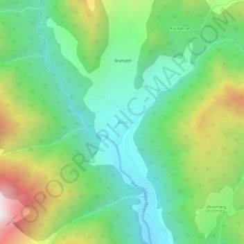
Nom : Carte topographique Aru, altitude, relief.
Lieu : Aru, Pahalgam, Anantnag District, Jammu and Kashmir, India (34.07030 75.24244 34.11030 75.28244)
Altitude moyenne : 2 764 m
Altitude minimum : 2 305 m
Altitude maximum : 3 691 m
Merci de soutenir ce site ❤️
Faire un don
Faire un don
Équipez-vous pour votre prochaine aventure :
En tant que Partenaire Amazon, ce site perçoit une commission sur les achats éligibles sans surcoût pour vous.