
Carte topographique Southside
Carte interactive
Cliquez sur la carte pour afficher l’altitude.
À propos de cette carte
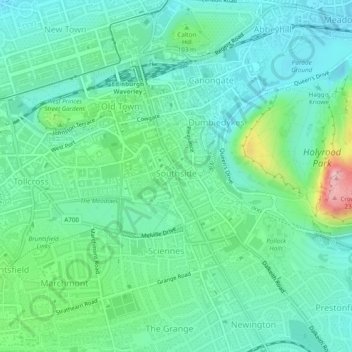
Nom : Carte topographique Southside, altitude, relief.
Altitude moyenne : 77 m
Altitude minimum : 26 m
Altitude maximum : 239 m
Autres cartes topographiques
Cliquez sur une carte pour visualiser sa topographie, son altitude et son relief.
Muirhouse/Salvesen
United Kingdom > Scotland > Edinburgh
Muirhouse/Salvesen, Edinburgh, City of Edinburgh, Scotland, United Kingdom
Altitude moyenne : 29 m
Agassiz Rock
United Kingdom > Scotland > Edinburgh
Agassiz Rock, Howe Dean Path, Braid Hills, Edinburgh, City of Edinburgh, Scotland, EH16 6TR, United Kingdom
Altitude moyenne : 109 m
Old Town
United Kingdom > Scotland > Edinburgh
Old Town, Edinburgh, City of Edinburgh, Scotland, United Kingdom
Altitude moyenne : 61 m
Arthur's Seat
United Kingdom > Scotland > Edinburgh
Arthur's Seat, Edinburgh, City of Edinburgh, Scotland, EH8 8HG, United Kingdom
Altitude moyenne : 69 m