
Carte topographique Bulwar WSK Rzeszów
Carte interactive
Cliquez sur la carte pour afficher l’altitude.
À propos de cette carte
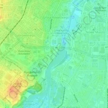
Nom : Carte topographique Bulwar WSK Rzeszów, altitude, relief.
Altitude moyenne : 208 m
Altitude minimum : 193 m
Altitude maximum : 232 m
Autres cartes topographiques
Cliquez sur une carte pour visualiser sa topographie, son altitude et son relief.
Town Centre
Poland > Subcarpathian Voivodeship > Rzeszów
Town Centre, Rzeszów, Subcarpathian Voivodeship, Poland
Altitude moyenne : 207 m