
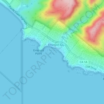
Carte topographique Emerald Bay
Carte interactive
Cliquez sur la carte pour afficher l’altitude.
À propos de cette carte
Nom : Carte topographique Emerald Bay, altitude, relief.
Altitude moyenne : 37 m
Altitude minimum : -1 m
Altitude maximum : 219 m
Autres cartes topographiques
Cliquez sur une carte pour visualiser sa topographie, son altitude et son relief.
Top of the World
United States > California > Orange County > Laguna Beach
Top of the World, Laguna Beach, Orange County, California, 92651, United States
Altitude moyenne : 133 m
South Laguna
United States > California > Orange County > Laguna Beach
South Laguna, Laguna Beach, Orange County, CAL Fire Southern Region, California, 92607, United States
Altitude moyenne : 64 m
Three Arch Bay
United States > California > Orange County > Laguna Beach
Three Arch Bay, Laguna Beach, Orange County, CAL Fire Southern Region, California, 92629, United States
Altitude moyenne : 57 m