
Carte topographique Bathurst
Carte interactive
Cliquez sur la carte pour afficher l’altitude.
À propos de cette carte
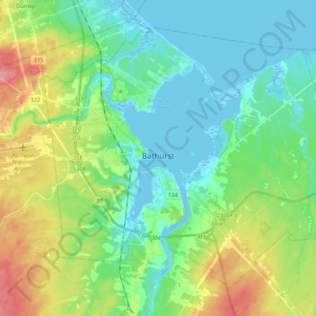
Nom : Carte topographique Bathurst, altitude, relief.
Altitude moyenne : 26 m
Altitude minimum : -5 m
Altitude maximum : 88 m
Autres cartes topographiques
Cliquez sur une carte pour visualiser sa topographie, son altitude et son relief.
Pabineau Falls
Canada > New Brunswick > Bathurst Parish
Pabineau Falls, Bathurst Parish, Gloucester County, New Brunswick, Canada
Altitude moyenne : 47 m
Chamberlain Settlement
Canada > New Brunswick > Bathurst Parish
Chamberlain Settlement, Bathurst Parish, Gloucester County, New Brunswick, E2A 3Z2, Canada
Altitude moyenne : 46 m