
Faire un don
Équipez-vous pour votre prochaine aventure :
En tant que Partenaire Amazon, ce site perçoit une commission sur les achats éligibles sans surcoût pour vous.
Carte topographique Mount Banahaw
Cliquez sur la carte pour afficher l’altitude.
Faire un don
Équipez-vous pour votre prochaine aventure :
En tant que Partenaire Amazon, ce site perçoit une commission sur les achats éligibles sans surcoût pour vous.
Mount Banahaw
The andesitic Banahaw volcanic complex is composed of several stratovolcanoes with Mount Banahaw, the largest with a maximum elevation of 2,170 metres (7,119 ft) above mean sea level. The summit is topped by a 1.5 by 3.5 kilometres (0.93 mi × 2.17 mi) and 210 metres (690 ft) deep crater that is breached on the southern rim believed to have been caused by the 1730 eruption. Prior to 1730, a lake occupied the summit crater of Mount Banahaw. The resulting flood destroyed the town of Sariaya, Quezon located below the mountain.[7]
Faire un don
Équipez-vous pour votre prochaine aventure :
En tant que Partenaire Amazon, ce site perçoit une commission sur les achats éligibles sans surcoût pour vous.
À propos de cette carte
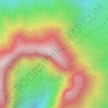
Nom : Carte topographique Mount Banahaw, altitude, relief.
Altitude moyenne : 1 730 m
Altitude minimum : 1 261 m
Altitude maximum : 2 145 m
Faire un don
Équipez-vous pour votre prochaine aventure :
En tant que Partenaire Amazon, ce site perçoit une commission sur les achats éligibles sans surcoût pour vous.