
Carte topographique Cheyenne
Carte interactive
Cliquez sur la carte pour afficher l’altitude.
À propos de cette carte
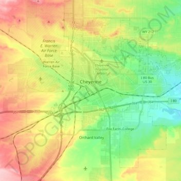
Nom : Carte topographique Cheyenne, altitude, relief.
Lieu : Cheyenne, Laramie County, Wyoming, United States (41.07310 -104.86112 41.19303 -104.67493)
Altitude moyenne : 1 871 m
Altitude minimum : 1 803 m
Altitude maximum : 1 962 m
The Cheyenne Regional Airport was opened in 1920, initially serving as a stop for airmail. It soon developed into a civil-military airport, serving DC-3s and various military craft. During World War II, hundreds of B-17s, B-24s, and PBYs were outfitted and upgraded at the airfield. Today, it serves a number of military functions, and as a high-altitude testbed for civilian craft.
Autres cartes topographiques
Cliquez sur une carte pour visualiser sa topographie, son altitude et son relief.
Cheyenne
United States > Wyoming > Laramie County > Cheyenne
Cheyenne, Laramie County, Wyoming, 82002, United States
Altitude moyenne : 1 891 m