
Carte topographique Untergriesbach
Carte interactive
Cliquez sur la carte pour afficher l’altitude.
À propos de cette carte
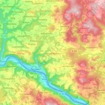
Nom : Carte topographique Untergriesbach, altitude, relief.
Lieu : Untergriesbach, Landkreis Passau, Bavaria, 94107, Germany (48.51302 13.58171 48.63615 13.75572)
Altitude moyenne : 538 m
Altitude minimum : 278 m
Altitude maximum : 839 m
Autres cartes topographiques
Cliquez sur une carte pour visualiser sa topographie, son altitude et son relief.
Muth
Germany > Bavaria > Landkreis Passau > Loizersdorf
Muth, Loizersdorf, Tittling, Tittling (VGem), Landkreis Passau, Bavaria, 94104, Germany
Altitude moyenne : 474 m
Hutthurm
Germany > Bavaria > Landkreis Passau
Hutthurm, Landkreis Passau, Bavaria, 94116, Germany
Altitude moyenne : 432 m
Dobl
Germany > Bavaria > Landkreis Passau > Vilshofen an der Donau > Dobl
Dobl, Vilshofen an der Donau, Landkreis Passau, Bavaria, 94474, Germany
Altitude moyenne : 398 m