
Carte topographique Tullysaran
Carte interactive
Cliquez sur la carte pour afficher l’altitude.
À propos de cette carte
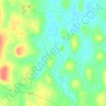
Nom : Carte topographique Tullysaran, altitude, relief.
Lieu : Tullysaran, Armagh, Northern Ireland, United Kingdom (54.37432 -6.73522 54.38419 -6.72486)
Altitude moyenne : 36 m
Altitude minimum : 13 m
Altitude maximum : 75 m
Autres cartes topographiques
Cliquez sur une carte pour visualiser sa topographie, son altitude et son relief.
Derryfubble
United Kingdom > Northern Ireland > Armagh
Derryfubble, Armagh, Northern Ireland, United Kingdom
Altitude moyenne : 63 m
Drumay
United Kingdom > Northern Ireland > Armagh
Drumay, Armagh, Northern Ireland, United Kingdom
Altitude moyenne : 58 m
Ballymartrim Etra
United Kingdom > Northern Ireland > Armagh
Ballymartrim Etra, Armagh, Northern Ireland, United Kingdom
Altitude moyenne : 32 m
Blackwater
United Kingdom > Northern Ireland > Armagh
Blackwater, Armagh, County Armagh, Northern Ireland, United Kingdom
Altitude moyenne : 44 m
Killylea
United Kingdom > Northern Ireland > Armagh
Killylea, Armagh, County Armagh, Northern Ireland, BT60 4LN, United Kingdom
Altitude moyenne : 75 m
Mullenakill West
United Kingdom > Northern Ireland > Armagh
Mullenakill West, Armagh, County Armagh, Northern Ireland, United Kingdom
Altitude moyenne : 17 m
Creaghan
United Kingdom > Northern Ireland > Armagh
Creaghan, Armagh, County Armagh, Northern Ireland, United Kingdom
Altitude moyenne : 28 m