
Carte topographique Scandinavian Mountains
Carte interactive
Cliquez sur la carte pour afficher l’altitude.
À propos de cette carte
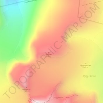
Nom : Carte topographique Scandinavian Mountains, altitude, relief.
Lieu : Scandinavian Mountains, Lom, Innlandet, Norway (61.64995 8.31995 61.65005 8.32005)
Altitude moyenne : 2 050 m
Altitude minimum : 1 484 m
Altitude maximum : 2 467 m
The mountain chain's highest summits are mostly concentrated in an area (of mean altitude of over 1,000 m) between Stavanger and Trondheim in South Norway, with numerous peaks over 1,300 m and some peaks over 2,000 m. Around Trondheim Fjord, peaks decrease in altitude to about 400–500 m rising again to heights in excess of 1,900 m further north in Swedish Lapland and nearby areas of Norway. The southern part of the mountain range contains the highest mountain of Northern Europe, Galdhøpiggen at almost 2,500 m. This part of the mountain chain is also broader and contains a series of plateaux and gently undulating surfaces that hosts scattered inselbergs. The plateaux and undulating surfaces of the southern Scandinavian Mountains form a series of stepped surfaces. Geomorphologist Karna Lidmar-Bergström and co-workers recognize five widespread stepped surfaces. In eastern Norway, some of the stepped surfaces merge into a single surface. Dovre and Jotunheimen are rises from the highest of the stepped surfaces. In south-western Norway, the plateaux and gently undulating surfaces are strongly dissected by fjords and valleys. The mountain chain is present in Sweden from northern Dalarna northwards; south of this point the Scandinavian Mountains lie completely within Norway. Most of the Scandinavian Mountains lack "alpine topography", and where present it does not relate to altitude. An example of this is the distribution of cirques in southern Norway that can be found both near sea level and at 2,000 m. Most cirques are found between 1,000 and 1,500 m.
Autres cartes topographiques
Cliquez sur une carte pour visualiser sa topographie, son altitude et son relief.
Li
Norway > Innlandet > Skammestein
Li, Skammestein, Øystre Slidre, Innlandet, 2950, Norway
Altitude moyenne : 774 m
Fregn naturreservat
Fregn naturreservat, Trysil, Innlandet, Norway
Altitude moyenne : 673 m
Viewpoint Snøhetta
Viewpoint Snøhetta, Vålåsjøhøvegen, Dovre, Innlandet, 2661, Norway
Altitude moyenne : 1 157 m
Beitostølen
Beitostølen, Øystre Slidre, Innlandet, 2953, Norway
Altitude moyenne : 914 m