
Carte topographique Torsby kommun
Carte interactive
Cliquez sur la carte pour afficher l’altitude.
À propos de cette carte
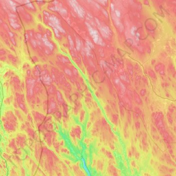
Nom : Carte topographique Torsby kommun, altitude, relief.
Lieu : Torsby kommun, Värmland County, Sweden (60.03315 12.22399 61.05600 13.62195)
Altitude moyenne : 356 m
Altitude minimum : 57 m
Altitude maximum : 742 m
Autres cartes topographiques
Cliquez sur une carte pour visualiser sa topographie, son altitude et son relief.
Ekshärad
Ekshärad, Hagfors kommun, Värmland County, 680 50, Sweden
Altitude moyenne : 174 m
Breviken
Breviken, Årjängs kommun, Värmland County, 672 91, Sweden
Altitude moyenne : 135 m
Pottern
Pottern, Storfors kommun, Värmland County, Sweden
Altitude moyenne : 145 m
Nysäter
Nysäter, Säffle kommun, Värmland County, 661 95, Sweden
Altitude moyenne : 84 m
Charlottenberg
Charlottenberg, Eda kommun, Värmland County, 673 22, Sweden
Altitude moyenne : 143 m
Karlstads kommun
Karlstads kommun, Värmland County, Sweden
Altitude moyenne : 109 m
Dye
Sweden > Värmland County > Karlstad
Dye, Karlstad, Karlstads kommun, Värmland County, 653 47, Sweden
Altitude moyenne : 61 m
Lekvattnet
Lekvattnet, Lekvattnet distrikt, Torsby kommun, Värmland County, Sweden
Altitude moyenne : 290 m
Filipstads kommun
Filipstads kommun, Värmland County, Sweden
Altitude moyenne : 241 m
Storfors kommun
Storfors kommun, Värmland County, Sweden
Altitude moyenne : 158 m
Bograngen
Sweden > Värmland County > Bograngen
Bograngen, Södra Finnskoga distrikt, Torsby kommun, Värmland County, 68061, Sweden
Altitude moyenne : 344 m
Karlstad
Karlstad, Karlstads kommun, Värmland County, 652 24, Sweden
Altitude moyenne : 61 m
Norra Rådom
Sweden > Värmland County > Norra Rådom
Norra Rådom, Karlstads kommun, Värmland County, Sweden
Altitude moyenne : 111 m
Molkom
Sweden > Värmland County > Molkom
Molkom, Karlstads kommun, Värmland County, 655 60, Sweden
Altitude moyenne : 92 m
Hagfors kommun
Hagfors kommun, Värmland County, Sweden
Altitude moyenne : 256 m