
Carte topographique Battle of Waterloo
Carte interactive
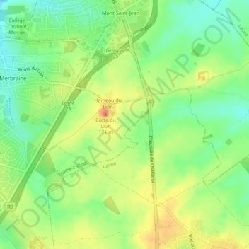
Cliquez sur la carte pour afficher l’altitude.
À propos de cette carte
Nom : Carte topographique Battle of Waterloo, altitude, relief.
Altitude moyenne : 121 m
Altitude minimum : 96 m
Altitude maximum : 149 m
Waterloo was the decisive engagement of the Waterloo Campaign and Napoleon's last. According to Wellington, the battle was "the nearest-run thing you ever saw in your life". Napoleon abdicated four days later, and coalition forces entered Paris on 7 July. The defeat at Waterloo ended Napoleon's rule as Emperor of the French and marked the end of his Hundred Days return from exile. This ended the First French Empire and set a chronological milestone between serial European wars and decades of relative peace, often referred to as the Pax Britannica. The battlefield is located in the Belgian municipalities of Braine-l'Alleud and Lasne, about 15 kilometres (9.3 mi) south of Brussels, and about 2 kilometres (1.2 mi) from the town of Waterloo. The site of the battlefield today is dominated by the monument of the Lion's Mound, a large artificial hill constructed from earth taken from the battlefield itself; the topography of the battlefield near the mound has not been preserved.
Autres cartes topographiques
Cliquez sur une carte pour visualiser sa topographie, son altitude et son relief.
Mont-Saint-Jean
Belgium > Walloon Brabant > Waterloo
Mont-Saint-Jean, Waterloo, Nivelles, Walloon Brabant, Wallonia, 1410, Belgium
Altitude moyenne : 117 m