
Faire un don
Équipez-vous pour votre prochaine aventure :
En tant que Partenaire Amazon, ce site perçoit une commission sur les achats éligibles sans surcoût pour vous.
Carte topographique El Barrancón Norte
Cliquez sur la carte pour afficher l’altitude.
Faire un don
Équipez-vous pour votre prochaine aventure :
En tant que Partenaire Amazon, ce site perçoit une commission sur les achats éligibles sans surcoût pour vous.
À propos de cette carte
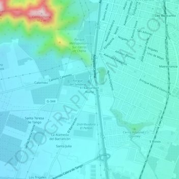
Nom : Carte topographique El Barrancón Norte, altitude, relief.
Altitude moyenne : 571 m
Altitude minimum : 521 m
Altitude maximum : 922 m
Faire un don
Équipez-vous pour votre prochaine aventure :
En tant que Partenaire Amazon, ce site perçoit une commission sur les achats éligibles sans surcoût pour vous.
Autres cartes topographiques
Cliquez sur une carte pour visualiser sa topographie, son altitude et son relief.
Paine
Chile > Santiago Metropolitan Region > Provincia de Maipo
The Aculeo Lagoon was located within the commune of Paine, it was one of the main recreation centers for the people of Santiago and the only natural lagoon in the region. There are various campsites in the sector. In its territory are also the Altos de Cantillana, a natural reserve consisting of high-altitude…
Altitude moyenne : 815 m