
Faire un don
Équipez-vous pour votre prochaine aventure :
En tant que Partenaire Amazon, ce site perçoit une commission sur les achats éligibles sans surcoût pour vous.
Carte topographique Navajo Dam
Cliquez sur la carte pour afficher l’altitude.
Faire un don
Équipez-vous pour votre prochaine aventure :
En tant que Partenaire Amazon, ce site perçoit une commission sur les achats éligibles sans surcoût pour vous.
À propos de cette carte
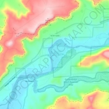
Nom : Carte topographique Navajo Dam, altitude, relief.
Altitude moyenne : 1 813 m
Altitude minimum : 1 721 m
Altitude maximum : 1 974 m
Faire un don
Équipez-vous pour votre prochaine aventure :
En tant que Partenaire Amazon, ce site perçoit une commission sur les achats éligibles sans surcoût pour vous.
Autres cartes topographiques
Cliquez sur une carte pour visualiser sa topographie, son altitude et son relief.
Farmington
United States > New Mexico > San Juan County
Farmington has a semi-arid climate. Despite its altitude of 5,473 feet (1,668 m), the city can experience hot summers and cold winters with low precipitation throughout the year. The average annual snowfall is 12.3 inches (31 cm).
Altitude moyenne : 1 698 m
Aztec
United States > New Mexico > San Juan County
Yet another area managed by the BLM, this area was formed about the same time as the Bisti and Ah-Shi-Sle-Pah. This region offers a uniquely different scale of landscape. Hoodoo in this region are massive and the terrain much greater in elevation differences, thereby exposing a greater geological time frame…
Altitude moyenne : 1 803 m
Faire un don
Équipez-vous pour votre prochaine aventure :
En tant que Partenaire Amazon, ce site perçoit une commission sur les achats éligibles sans surcoût pour vous.
Faire un don
Équipez-vous pour votre prochaine aventure :
En tant que Partenaire Amazon, ce site perçoit une commission sur les achats éligibles sans surcoût pour vous.
El Paso Natural Gas Dam Number 5
United States > New Mexico > San Juan County > Kirtland
Altitude moyenne : 1 604 m
Farmington
United States > New Mexico > San Juan County
Farmington has a semi-arid climate. Despite its altitude of 5,473 feet (1,668 m), the city can experience hot summers and cold winters with low precipitation throughout the year. The average annual snowfall is 12.3 inches (31 cm).
Altitude moyenne : 1 698 m
Faire un don
Équipez-vous pour votre prochaine aventure :
En tant que Partenaire Amazon, ce site perçoit une commission sur les achats éligibles sans surcoût pour vous.
Aztec
United States > New Mexico > San Juan County
Yet another area managed by the BLM, this area was formed about the same time as the Bisti and Ah-Shi-Sle-Pah. This region offers a uniquely different scale of landscape. Hoodoo in this region are massive and the terrain much greater in elevation differences, thereby exposing a greater geological time frame…
Altitude moyenne : 1 803 m
Aztec
United States > New Mexico > San Juan County > Aztec
Yet another area managed by the BLM, this area was formed about the same time as the Bisti and Ah-Shi-Sle-Pah. This region offers a uniquely different scale of landscape. Hoodoo in this region are massive and the terrain much greater in elevation differences, thereby exposing a greater geological time frame…
Altitude moyenne : 1 776 m
Faire un don
Équipez-vous pour votre prochaine aventure :
En tant que Partenaire Amazon, ce site perçoit une commission sur les achats éligibles sans surcoût pour vous.