
Carte topographique Homer
Carte interactive
Cliquez sur la carte pour afficher l’altitude.
À propos de cette carte
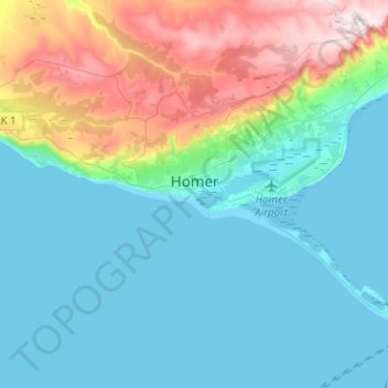
Nom : Carte topographique Homer, altitude, relief.
Lieu : Homer, Kenai Peninsula, Alaska, United States (59.59827 -151.65504 59.68130 -151.40400)
Altitude moyenne : 103 m
Altitude minimum : 0 m
Altitude maximum : 449 m
Many of the birds seen during the festival can be identified with the help of published guides that categorize distinguishable features such as, topography, silhouette, size, and color.