
Faire un don
Équipez-vous pour votre prochaine aventure :
En tant que Partenaire Amazon, ce site perçoit une commission sur les achats éligibles sans surcoût pour vous.
Carte topographique Pignola
Cliquez sur la carte pour afficher l’altitude.
Faire un don
Équipez-vous pour votre prochaine aventure :
En tant que Partenaire Amazon, ce site perçoit une commission sur les achats éligibles sans surcoût pour vous.
Pignola
Pignola is an Italian town in the province of Potenza in Basilicata. It borders to the east with Anzi, to the south-west with Abriola, to the west with Tito and to the north with Potenza. The Pignolese territory extends for 55.51 km2 and has an altitude ranging from 700 m of Pantano-Petrucco to 927 m of the inhabited center, up to 1476 m of Mount Serranetta which represents the highest point of the Pignolese territory. It has 6,962 inhabitants.
Faire un don
Équipez-vous pour votre prochaine aventure :
En tant que Partenaire Amazon, ce site perçoit une commission sur les achats éligibles sans surcoût pour vous.
À propos de cette carte
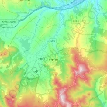
Nom : Carte topographique Pignola, altitude, relief.
Lieu : Pignola, Potenza, Basilicata, 85010, Italy (40.54255 15.72437 40.61478 15.86239)
Altitude moyenne : 929 m
Altitude minimum : 655 m
Altitude maximum : 1 475 m
Faire un don
Équipez-vous pour votre prochaine aventure :
En tant que Partenaire Amazon, ce site perçoit une commission sur les achats éligibles sans surcoût pour vous.
Autres cartes topographiques
Cliquez sur une carte pour visualiser sa topographie, son altitude et son relief.