
Carte topographique Gothenburg
Carte interactive
Cliquez sur la carte pour afficher l’altitude.
À propos de cette carte
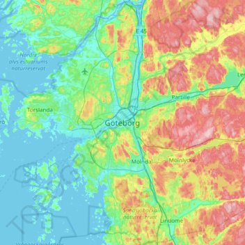
Nom : Carte topographique Gothenburg, altitude, relief.
Altitude moyenne : 45 m
Altitude minimum : -4 m
Altitude maximum : 158 m
Autres cartes topographiques
Cliquez sur une carte pour visualiser sa topographie, son altitude et son relief.
Brännö
Sweden > Västra Götaland County > Gothenburg
Brännö, Gothenburg, Göteborgs Stad, Västra Götaland County, Region Götaland, 43085, Sweden
Altitude moyenne : 6 m