
Faire un don
Équipez-vous pour votre prochaine aventure :
En tant que Partenaire Amazon, ce site perçoit une commission sur les achats éligibles sans surcoût pour vous.
Carte topographique Monument
Cliquez sur la carte pour afficher l’altitude.
Faire un don
Équipez-vous pour votre prochaine aventure :
En tant que Partenaire Amazon, ce site perçoit une commission sur les achats éligibles sans surcoût pour vous.
Monument
Monument experiences a hemiboreal continental climate (Köppen Dfb) with warm, relatively rainy summers and cold, snowy winters. The semi-arid climate keeps the dew point very low in Monument year-round which causes the air to feel quite dry. Monument is part of the Front Range urban corridor and lies on the southern slope of Monument Hill. The town is situated near the western terminus of the Palmer Divide, a low-grade ridge that extends eastward from the Front Range and has a significant impact on Monument's climate. With Monument Hill reaching 7,352 feet above sea level, Monument is one of the highest communities in the Front Range urban corridor. The combination of high elevation, uniquely situated geography, semi-arid climate, and freezing cold winter months, the town of Monument receives considerably more snow each year than its neighboring cities. Colorado Springs (20 miles to the South) receives an average of 33 inches of snow per year and Denver (53 miles to the North) receives an average of 56 inches of snow per year, whereas the town of Monument receives an average of 110 inches of snow per year.
Faire un don
Équipez-vous pour votre prochaine aventure :
En tant que Partenaire Amazon, ce site perçoit une commission sur les achats éligibles sans surcoût pour vous.
À propos de cette carte
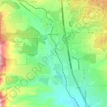
Nom : Carte topographique Monument, altitude, relief.
Lieu : Monument, El Paso County, Colorado, United States (39.04220 -104.88472 39.11504 -104.79116)
Altitude moyenne : 2 160 m
Altitude minimum : 2 035 m
Altitude maximum : 2 409 m
Faire un don
Équipez-vous pour votre prochaine aventure :
En tant que Partenaire Amazon, ce site perçoit une commission sur les achats éligibles sans surcoût pour vous.
Autres cartes topographiques
Cliquez sur une carte pour visualiser sa topographie, son altitude et son relief.
Colorado Springs
United States > Colorado > El Paso County > Colorado Springs
Snowfall is usually moderate and remains on the ground briefly because of direct sun, with the city receiving 38 inches (97 cm) per season, although the mountains to the west often receive in excess of triple that amount; March is the snowiest month in the region, both by total accumulation and number of days…
Altitude moyenne : 2 229 m