
Carte topographique Nkange
Carte interactive
Cliquez sur la carte pour afficher l’altitude.
À propos de cette carte
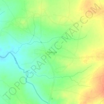
Nom : Carte topographique Nkange, altitude, relief.
Lieu : Nkange, Central District, Botswana (-20.31818 27.11670 -20.27818 27.15670)
Altitude moyenne : 1 105 m
Altitude minimum : 1 086 m
Altitude maximum : 1 126 m
Autres cartes topographiques
Cliquez sur une carte pour visualiser sa topographie, son altitude et son relief.
Boteti River
Boteti River, Central District, Botswana
Altitude moyenne : 914 m
Makgadikgadi Pans Game Reserve
Makgadikgadi Pans Game Reserve, Central District, Botswana
Altitude moyenne : 917 m
Selebi Phikwe
Botswana > Central District > Selebi Phikwe
Selebi Phikwe, Central District, Botswana
Altitude moyenne : 863 m