
Carte topographique Warstein
Carte interactive
Cliquez sur la carte pour afficher l’altitude.
Warstein
Warstein is located north of the Arnsberger Wald (forest) at a brook called Wäster. The area south of the city is mostly forested; the lightly forested Haarstrang mountain is to the north. The river Möhne flows between these two areas. The highest elevation is 581 m (1,906 ft) in the south of the city near a hill called Stimm Stamm; the lowest elevation is 216 m (709 ft) in the village Waldhausen in the north.
À propos de cette carte
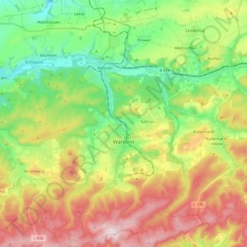
Nom : Carte topographique Warstein, altitude, relief.
Lieu : Warstein, Kreis Soest, North Rhine-Westphalia, 59581, Germany (51.38855 8.20178 51.52277 8.40984)
Altitude moyenne : 373 m
Altitude minimum : 223 m
Altitude maximum : 582 m
Autres cartes topographiques
Cliquez sur une carte pour visualiser sa topographie, son altitude et son relief.