
Carte topographique Crowborough
Carte interactive
Cliquez sur la carte pour afficher l’altitude.
À propos de cette carte
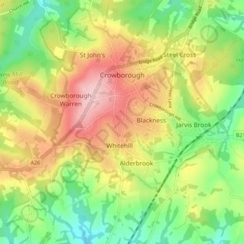
Nom : Carte topographique Crowborough, altitude, relief.
Lieu : Crowborough, Wealden, East Sussex, England, United Kingdom (51.02955 0.11916 51.06922 0.19790)
Altitude moyenne : 146 m
Altitude minimum : 64 m
Altitude maximum : 244 m
In the late 19th century, Crowborough was promoted as a health resort based on its high elevation, the rolling hills and surrounding forest. Estate Agents even called it "Scotland in Sussex". The town's golf course opened in 1895, followed by a fire station and hospital in 1900.
Autres cartes topographiques
Cliquez sur une carte pour visualiser sa topographie, son altitude et son relief.
Seven Sisters
United Kingdom > England > East Sussex > Wealden > Friston
Seven Sisters, Crowlink Lane, East Dean and Friston, Friston, Wealden, East Sussex, England, BN20 0BA, United Kingdom
Altitude moyenne : 35 m