
Carte topographique powiat krośnieński
Carte interactive
Cliquez sur la carte pour afficher l’altitude.
À propos de cette carte
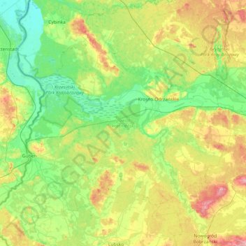
Nom : Carte topographique powiat krośnieński, altitude, relief.
Lieu : powiat krośnieński, Lubusz Voivodeship, Poland (51.78488 14.58961 52.23364 15.31440)
Altitude moyenne : 67 m
Altitude minimum : 22 m
Altitude maximum : 169 m
Autres cartes topographiques
Cliquez sur une carte pour visualiser sa topographie, son altitude et son relief.
Kostrzyn nad Odrą
Poland > Lubusz Voivodeship > Gorzów County > Kostrzyn nad Odrą
Kostrzyn nad Odrą, Gorzów County, Lubusz Voivodeship, 66-470, Poland
Altitude moyenne : 29 m
Zielona Góra
Poland > Lubusz Voivodeship > Zielona Góra
Zielona Góra, Lubusz Voivodeship, Poland
Altitude moyenne : 87 m
Greuswerder
Poland > Lubusz Voivodeship > Słubice County > Nowy Lubusz
Greuswerder, Nowy Lubusz, gmina Słubice, Słubice County, Lubusz Voivodeship, 69-100, Poland
Altitude moyenne : 26 m
Zielona Góra
Zielona Góra, Lubusz Voivodeship, Poland
Altitude moyenne : 90 m
Świebodzin County
Świebodzin County, Lubusz Voivodeship, Poland
Altitude moyenne : 84 m
Ośno Lubuskie
Poland > Lubusz Voivodeship > Ośno Lubuskie
Ośno Lubuskie, gmina Ośno Lubuskie, Słubice County, Lubusz Voivodeship, 69-220, Poland
Altitude moyenne : 55 m
Jasień
Poland > Lubusz Voivodeship > Jasień
Jasień, gmina Jasień, powiat żarski, Lubusz Voivodeship, 68320, Poland
Altitude moyenne : 86 m
Olbrachtów
Poland > Lubusz Voivodeship > Olbrachtów
Olbrachtów, gmina Żary, powiat żarski, Lubusz Voivodeship, 68-200, Poland
Altitude moyenne : 186 m
Lubsza
Poland > Lubusz Voivodeship > Lubsko
Lubsza, Lubsko, gmina Lubsko, powiat żarski, Lubusz Voivodeship, 68-300, Poland
Altitude moyenne : 78 m
Gorzów Wielkopolski
Gorzów Wielkopolski, Lubusz Voivodeship, Poland
Altitude moyenne : 46 m
Lubsza
Poland > Lubusz Voivodeship > Jasień
Lubsza, Jasień, gmina Jasień, powiat żarski, Lubusz Voivodeship, 68320, Poland
Altitude moyenne : 84 m
Chociule
Poland > Lubusz Voivodeship > Chociule
Chociule, gmina Świebodzin, powiat świebodziński, Lubusz Voivodeship, Poland
Altitude moyenne : 93 m
Stare Bielice
Poland > Lubusz Voivodeship > Stare Bielice
Stare Bielice, gmina Drezdenko, powiat strzelecko-drezdenecki, Lubusz Voivodeship, 66-530, Poland
Altitude moyenne : 40 m
Gorzów County
Gorzów County, Lubusz Voivodeship, Poland
Altitude moyenne : 58 m