
Carte topographique Muskogee County
Carte interactive
Cliquez sur la carte pour afficher l’altitude.
À propos de cette carte
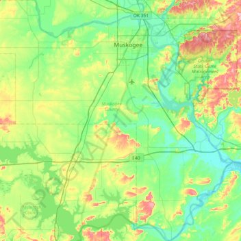
Nom : Carte topographique Muskogee County, altitude, relief.
Lieu : Muskogee County, Oklahoma, United States of America (35.26210 -95.76765 35.85766 -95.05057)
Altitude moyenne : 190 m
Altitude minimum : 141 m
Altitude maximum : 328 m
Autres cartes topographiques
Cliquez sur une carte pour visualiser sa topographie, son altitude et son relief.
Yukon
United States of America > Oklahoma > Yukon
Yukon, Oklahoma, United States of America
Altitude moyenne : 399 m
Alabaster Caverns State Park
United States of America > Oklahoma
Alabaster Caverns State Park, Woodward County, Oklahoma, United States of America
Altitude moyenne : 518 m
Keetonville
United States of America > Oklahoma > Keetonville
Keetonville, Rogers County, Oklahoma, United States of America
Altitude moyenne : 208 m
Fallis
United States of America > Oklahoma > Fallis
Fallis, Oklahoma, United States of America
Altitude moyenne : 284 m