
Faire un don
Équipez-vous pour votre prochaine aventure :
En tant que Partenaire Amazon, ce site perçoit une commission sur les achats éligibles sans surcoût pour vous.
Carte topographique Greetsiel
Cliquez sur la carte pour afficher l’altitude.
Faire un don
Équipez-vous pour votre prochaine aventure :
En tant que Partenaire Amazon, ce site perçoit une commission sur les achats éligibles sans surcoût pour vous.
À propos de cette carte
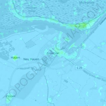
Nom : Carte topographique Greetsiel, altitude, relief.
Altitude moyenne : -1 m
Altitude minimum : -5 m
Altitude maximum : 6 m
Faire un don
Équipez-vous pour votre prochaine aventure :
En tant que Partenaire Amazon, ce site perçoit une commission sur les achats éligibles sans surcoût pour vous.
Autres cartes topographiques
Cliquez sur une carte pour visualiser sa topographie, son altitude et son relief.
Juist
Germany > Lower Saxony > Landkreis Aurich
Juist is accessible by plane or daily ferry. FLN Frisia Luftverkehr operates planes between Norden and Juist. Most motor vehicles are prohibited on the island, with only the fire department, the German Red Cross and doctors allowed to use them. Island tractors require a special license, while most other…
Altitude moyenne : 0 m
Faire un don
Équipez-vous pour votre prochaine aventure :
En tant que Partenaire Amazon, ce site perçoit une commission sur les achats éligibles sans surcoût pour vous.
Wiesmoor
Germany > Lower Saxony > Landkreis Aurich
On Friday 13 January 1989, a half year after the Ramstein Airshow Disaster, there was a collision of several military jets at low altitude over the Hinrichsfehn area of Wiesmoor. A tornado of the Royal Air Force collided with a squadron of German Alphas Jets of the Jagdbombergeschwader 43 division. One of the…
Altitude moyenne : 9 m
Faire un don
Équipez-vous pour votre prochaine aventure :
En tant que Partenaire Amazon, ce site perçoit une commission sur les achats éligibles sans surcoût pour vous.