
Carte topographique Monbay Lower
Carte interactive
Cliquez sur la carte pour afficher l’altitude.
À propos de cette carte
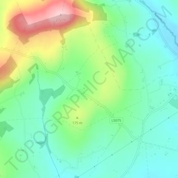
Nom : Carte topographique Monbay Lower, altitude, relief.
Altitude moyenne : 136 m
Altitude minimum : 73 m
Altitude maximum : 271 m
Autres cartes topographiques
Cliquez sur une carte pour visualiser sa topographie, son altitude et son relief.
Wexford
Wexford, The Borough District of Wexford, County Wexford, Leinster, Ireland
Altitude moyenne : 23 m
North West Slob
North West Slob, Ardcavan ED, The Borough District of Wexford, County Wexford, Leinster, Ireland
Altitude moyenne : 1 m
Hollyfort
Hollyfort, The Municipal District of Gorey — Kilmuckridge, County Wexford, Leinster, Ireland
Altitude moyenne : 145 m
The Municipal District of Gorey — Kilmuckridge
The Municipal District of Gorey — Kilmuckridge, County Wexford, Leinster, Ireland
Altitude moyenne : 58 m
Sow
Sow, Artramon ED, The Borough District of Wexford, County Wexford, Leinster, Y35 R889, Ireland
Altitude moyenne : 47 m
The Borough District of Wexford
The Borough District of Wexford, County Wexford, Leinster, Ireland
Altitude moyenne : 29 m