
Carte topographique Osthofen
Carte interactive
Cliquez sur la carte pour afficher l’altitude.
À propos de cette carte
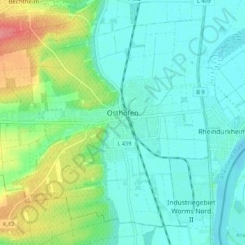
Nom : Carte topographique Osthofen, altitude, relief.
Altitude moyenne : 105 m
Altitude minimum : 84 m
Altitude maximum : 167 m
Autres cartes topographiques
Cliquez sur une carte pour visualiser sa topographie, son altitude et son relief.
Alzey
Germany > Rhineland-Palatinate > Landkreis Alzey-Worms
Alzey, Landkreis Alzey-Worms, Rhineland-Palatinate, Germany
Altitude moyenne : 222 m
Wöllstein
Germany > Rhineland-Palatinate > Landkreis Alzey-Worms > Wöllstein
Wöllstein, Landkreis Alzey-Worms, Rhineland-Palatinate, 55597, Germany
Altitude moyenne : 153 m