
Carte topographique Smerillo
Carte interactive
Cliquez sur la carte pour afficher l’altitude.
À propos de cette carte
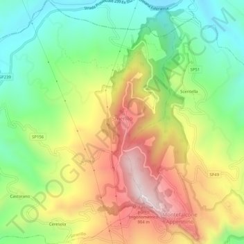
Nom : Carte topographique Smerillo, altitude, relief.
Lieu : Smerillo, Fermo, Marche, Italy (42.98615 13.40571 43.02301 13.45584)
Altitude moyenne : 538 m
Altitude minimum : 275 m
Altitude maximum : 881 m
Autres cartes topographiques
Cliquez sur une carte pour visualiser sa topographie, son altitude et son relief.
Porto San Giorgio
Porto San Giorgio, Fermo, Marche, 63822, Italy
Altitude moyenne : 33 m
Rovitolo
Italy > Marche > Fermo > Montefortino > Col Martese
Rovitolo, Col Martese, Montefortino, Fermo, Marche, 63858, Italy
Altitude moyenne : 586 m