
Faire un don
Équipez-vous pour votre prochaine aventure :
En tant que Partenaire Amazon, ce site perçoit une commission sur les achats éligibles sans surcoût pour vous.
Carte topographique Erbenschwang
Cliquez sur la carte pour afficher l’altitude.
Faire un don
Équipez-vous pour votre prochaine aventure :
En tant que Partenaire Amazon, ce site perçoit une commission sur les achats éligibles sans surcoût pour vous.
À propos de cette carte
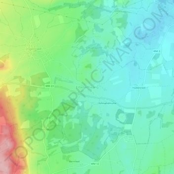
Nom : Carte topographique Erbenschwang, altitude, relief.
Altitude moyenne : 778 m
Altitude minimum : 727 m
Altitude maximum : 908 m
Faire un don
Équipez-vous pour votre prochaine aventure :
En tant que Partenaire Amazon, ce site perçoit une commission sur les achats éligibles sans surcoût pour vous.
Autres cartes topographiques
Cliquez sur une carte pour visualiser sa topographie, son altitude et son relief.
Hohenpeißenberg
Germany > Bavaria > Landkreis Weilheim-Schongau
The climate is oceanic (Köppen: Cfb), affected by altitude and proximity to the Alps (especially in precipitation). Registering data continuously since 1781, the Hohenpeißenberg Observatory is the oldest in the world located on a mountain. The station located in the alpine foothills integrates the German…
Altitude moyenne : 732 m
Faire un don
Équipez-vous pour votre prochaine aventure :
En tant que Partenaire Amazon, ce site perçoit une commission sur les achats éligibles sans surcoût pour vous.
Faire un don
Équipez-vous pour votre prochaine aventure :
En tant que Partenaire Amazon, ce site perçoit une commission sur les achats éligibles sans surcoût pour vous.